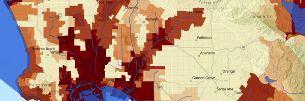
Impaired Waters
Environmental Effects Indicator
Counts pollutants in nearby streams, rivers, lakes, and coastal waters—contamination that can reach communities through fishing and recreation.
What are impaired waters?
Streams, rivers, and lakes are used for recreation and fishing and may provide water for drinking or agriculture. When water is contaminated by pollutants, the water bodies are considered impaired. These impairments are related to the amount of pollution that has occurred in or near the water body. Groups such as tribal or low-income communities may depend on fish, aquatic plants, and wildlife in nearby water bodies more than the general population.
Why is it included in CalEnviroScreen?
- Impairments can prevent recreational and other uses of the water body.
- Water pollution can harm wildlife habitats and change the number and types of plants and animals in the environment.
- When fish and shellfish are contaminated, people who eat them can be exposed to toxic substances.
How is it measured?
- The State Water Resources Control Board maintains information on water bodies in California that are impaired by pollutants. The indicator uses the most recent 2024 list of impaired water bodies.
- The indicator combines the number of pollutants in all water bodies designated as impaired in each census tract.