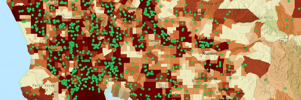
Groundwater Threats
Environmental Effects Indicator
Identifies sites that threaten groundwater quality near communities—including leaking storage tanks, dairies, and oil and gas operations.
What are groundwater threats?
Many activities can pose threats to groundwater quality. These include the storage and disposal of hazardous materials on land and in underground storage tanks at various types of commercial, industrial, and military sites. Thousands of storage tanks in California have leaked petroleum or other hazardous substances, degrading soil and groundwater. Dairy farms and concentrated animal-feeding operations, which produce large quantities of animal manure, also pose a threat to groundwater. Other activities that pose threats to groundwater quality include produced water ponds generated as a result of oil and gas development.
Why is it included in CalEnviroScreen?
- Leaking tanks can expose people to contaminated soil and air.
- People who live near contaminated groundwater may be exposed to chemicals moving from the soil into the air inside their homes.
- Some cancer-causing chemicals from cleanup sites have been found in drinking water supplies in California.
How is it measured?
- The State Water Resources Control Board maintains a database of places where groundwater may be threatened by certain sources of pollution. Groundwater threat data were downloaded in April 2026, and dairy and feedlot data were received in March 2026.
- The scores for sites that threaten groundwater quality are added together for each census tract.
- The score is based on information about the type of site and how close it is to neighborhoods where people live.