Wildfires

Credit: CampPhoto/Getty Images Signature
Wildfires are a natural part of California's landscape. Historically, much of the state’s forests had been adapted to periodic burning. However, this natural pattern has been disrupted by changes in land use, fire management practices, and the impact of climate change. Recent fires have led to tragic losses of lives, homes, and some of the state’s most iconic tree species: coast redwoods, giant sequoias, and Joshua trees. An increase in the number and severity of large wildfires throughout the western United States has been linked to hotter and drier conditions. Some experts are warning that the region has entered an era of "mega-fires." For more information, download the Wildfires chapter.
What does the indicator show?
Statewide annual acres burned, 1950-2024
This graph shows the number of acres (in millions) burned by wildfires in California each year.
Annual number of large wildfires, 1950-2024
This graph shows the number of large fires (10,000 acres or more) each year, with the red line indicating the 10-year moving average.
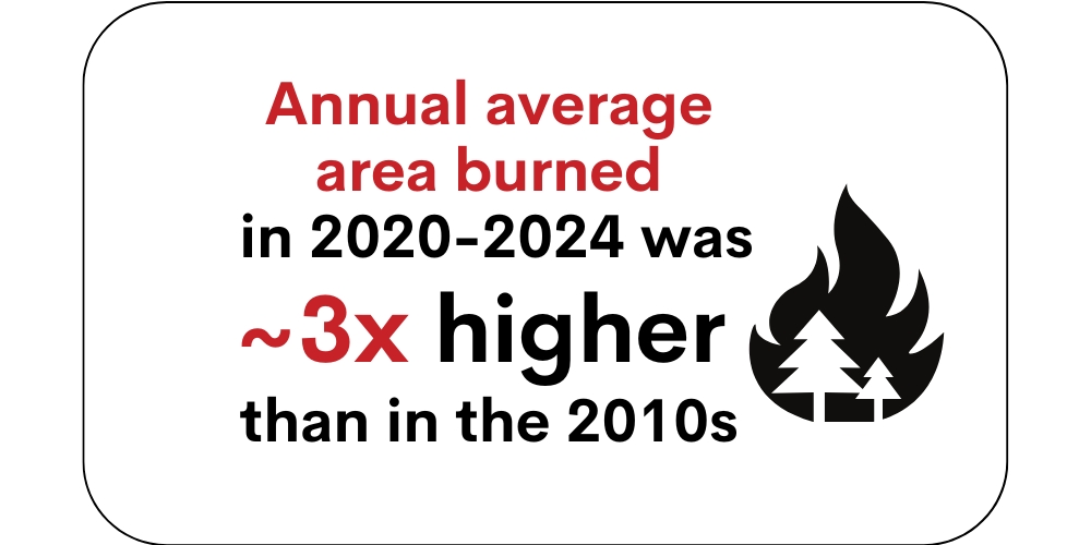
- Since 1950, the total area burned each year ranged from a low in 1963 of 32,000 acres to a record high in 2020 of 4.2 million acres – more than 4 percent of the state's roughly 100 million acres of land.
- The number of large fires (10,000 acres or more) has increased in the past two decades. All but two of the 20 largest wildfires between 1950 and 2024 occurred since 2000; ten of these burned in 2020 and 2021.
Why is this indicator important?
- Wildfires threaten public health and safety, property, infrastructure, and ecosystems. Wildfire smoke contains hazardous constituents that can severely impact air quality and human health, both locally and downwind.
- Wildfires lead to, and often accelerate, changes in the state’s forests and alter wildlife habitat. For example, after a wildfire, shrubs, grasses or hardwood trees regrow and replace conifers. The loss of forests means a loss of carbon storage capacity.
- Burn areas become vulnerable to runoff and erosion. The deposition of ash, sediment, debris, heavy metals from soils, and chemical contaminants into streams and rivers threatens aquatic organisms and drinking water sources.
What factors influence this indicator?
- Human‐caused warming has significantly enhanced wildfire activity in California and will likely continue to do so in the coming decades. Changes in aridity, seasonality, and incidence of severe weather conditions have all contributed to large wildfires. In addition, vegetation is now more likely to be dry in the fall when strong winds occur.
- California’s unprecedented drought and drought-related tree deaths in recent years increased the risk for extreme, high severity wildfires that spread rapidly.
- More than a century of fire suppression has led to the accumulation of fuels in California’s forests. Before Euro-American settlement, large areas of land were burned annually, ignited naturally by lightning and intentionally by Native Americans to manage the landscape.
- Land use and population changes affect ignition sources and fuel availability. For example, new housing in or near wildland vegetation has led to increased fire losses at the wildland-urban interface. The expansion of the electrical distribution system, much of it vulnerable to strong winds, increases risk of wildfires.
In 2020, 4.2 million acres burned in California, more than double the area burned in any previous year. The August Complex Fire of 2020 was the state’s first “gigafire”, having burned more than one million acres (left). The August Complex destroyed habitat for deer and other wildlife in the Mendocino, Six Rivers, and Shasta-Trinity National Forests (right).

Credit: USFS
Additional Resources
- California Department of Forestry and Fire Prevention, Fire and Resource Assessment Program and Statistics